
Travel Tips
Map of Great Britain Towns Counties and Popular Destinations

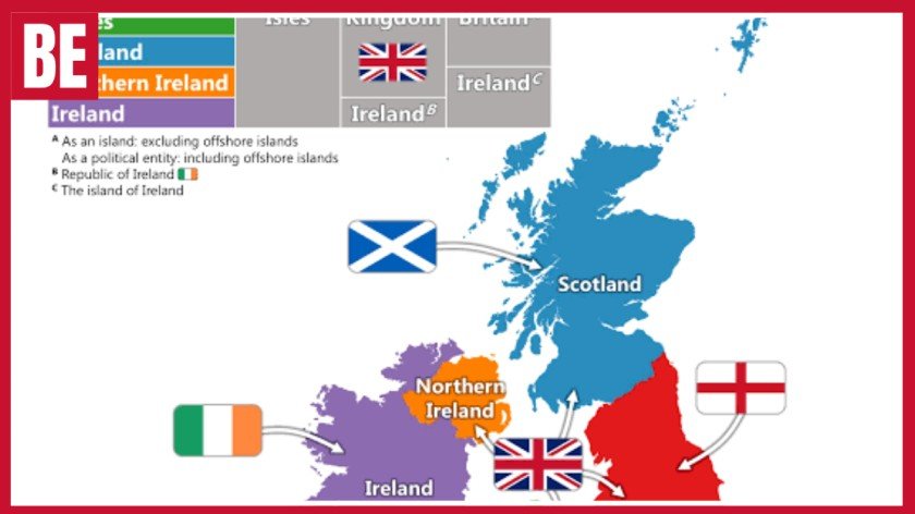
The map of Great Britain is important to help people also see how England, Scotland and Wales are related to each other through cities, towns, roads, rivers, mountains and coastline. Maps can be used for traveling, learning, studying for business purposes and general geographic information. Various maps show various types of information depending on what you need – political boundaries, ways of transport, places of interest, old boundaries and so on. The map of roads is helpful for motorists, and the tourist map helps to find interesting places to visit. Digital maps show up-to-date information, while paper maps give more comprehensive data., transport links and specialist mapping options available to users.
Understanding Great Britain and the UK Countries
Great Britain is the large island containing England, Scotland and Wales. It lies in north-western Europe and is surrounded by the Atlantic Ocean, North Sea, Irish Sea and English Channel. England occupies most of the southern and central area, Scotland covers the north, and Wales lies to the west of England. The island’s location has influenced its climate, trade, transport, culture and political history for centuries.
Great Britain is not the same as the United Kingdom. The United Kingdom consists of England, Scotland, Wales and Northern Ireland. Northern Ireland belongs to the UK but is situated on the island of Ireland. A UK country map should therefore display four countries, whereas a geographical outline of the main British island normally contains only England, Scotland and Wales. This distinction is important for students, travelers and anyone producing accurate geographical content.
The British Isles is a wider geographical term covering Great Britain, Ireland and many surrounding islands. These include Orkney, Shetland, the Hebrides, Isle of Wight, Isle of Man and Channel Islands. However, they do not all share the same political status. The Republic of Ireland is independent, while the Isle of Man and Channel Islands are Crown Dependencies. Readers should always check the title, scale and legend to understand exactly which territories are included.
Detailed UK Cities, Regions and Towns
London is the capital of England and the United Kingdom. It is situated in south-east England along the River Thames and is usually marked prominently because of its political, cultural and economic importance. Other major English cities include Birmingham, Manchester, Liverpool, Leeds, Sheffield, Bristol, Newcastle, Nottingham, Leicester and Southampton. These cities are connected by extensive road and railway networks and act as important regional centers.
Scotland occupies the northern part of the island. Edinburgh is its capital, while Glasgow is the largest city. Aberdeen, Dundee, Inverness, Perth and Stirling are also regularly displayed on detailed national maps. Most of the Scottish population lives in the Central Belt around Edinburgh and Glasgow. Northern and western Scotland contain larger mountain areas, island communities and lower population density, so settlements are often more widely separated.
Wales lies west of England and has Cardiff as its capital. Swansea, Newport, Wrexham, Bangor and St Davds are other recognized Welsh cities. Many modern Welsh maps use both Welsh and English place names, reflecting the importance of the Welsh language. A British towns map may also show places such as Blackpool, Reading, Harrogate, Shrewsbury, Fort William, Oban, St Andrews, Aberystwyth, Caernarfon and Tenby. Regional formats are better for locating smaller towns and villages because national designs have limited space.
Physical Landscape and Global Location
On a world map, Great Britain appears off the north-western coast of mainland Europe. France lies across the English Channel, Ireland is located to the west, and Belgium, the Netherlands, Germany, Denmark and Norway are positioned across the North Sea. The island’s maritime location creates relatively moderate temperatures, although weather can change quickly. Western regions generally receive more Atlantic rainfall, while eastern areas are often comparatively drier.
The landscape becomes higher and more mountainous towards the north and west. Scotland contains the Highlands, Cairngorms and Southern Uplands. Ben Nevis, situated near Fort William, is the highest mountain in Britain. Northern England contains the Pennines and Lake District, where Scafell Pike is the highest English mountain. Wales includes Eryri, the Cambrian Mountains and Bannau Brycheiniog. Yr Wyddfa, also known as Snowdon, is the highest point in Wales.
Major rivers include the Severn, Thames, Trent, Mersey, Tyne, Clyde, Tay and Forth. The Severn is generally recognised as Britain’s longest river, while the Thames flows through London. Scotland is known for Loch Ness and Loch Lomond, while England’s Lake District contains Windermere, Ullswater and Derwentwater. The coastline includes beaches, cliffs, estuaries, bays, islands and natural harbours. These physical features help explain settlement patterns, farming activity and transport development.
British Road Map and Transport Connections
A national road atlas displays motorways, A-roads, junctions, service areas, cities and regional routes. The M1 connects London with the Midlands and northern England. The M4 travels west from London through southern England and into South Wales. The M5 provides access to the south-west, while the M6 passes through the Midlands and north-west England towards Scotland. The M25 circles London, the M62 crosses northern England, and the M8 links Glasgow and Edinburgh.
Journey time cannot always be estimated from distance alone. Roads through Wales, Scotland and northern England may be narrow, steep or winding. Traffic congestion, roadworks, weather conditions and seasonal tourism can also cause delays. Digital navigation offers live traffic updates, while a printed road atlas provides a wider overview and helps drivers identify alternative routes. Using both options gives motorists better context and reliable backup when mobile signals or batteries fail.
Railway maps display major lines, stations and interchange points. Long-distance routes connect London with Birmingham, Manchester, Liverpool, Leeds, Newcastle, Edinburgh, Glasgow, Cardiff and Bristol. Transport guides may also mark airports such as Heathrow, Gatwick, Manchester, Birmingham, Edinburgh and Glasgow. Ferry ports including Dover, Portsmouth, Holyhead, Liverpool and Cairnryan connect Britain with Ireland, Northern Ireland, continental Europe and surrounding islands.
Tourist Guide to Britain’s Attractions
A tourist map for Great Britain highlights historical landmarks, castles, museums, national parks, beaches and scenic routes. London attractions include Buckingham Palace, the Tower of London, Westminster and major museums. Elsewhere in England, popular destinations include Windsor Castle, Stonehenge, Bath, Oxford, Cambridge, York and Hadrian’s Wall. The Cotswolds is known for traditional villages, while Cornwall and Devon attract visitors with beaches, cliffs and seaside towns.
Scotland offers historic cities, mountains, islands and lochs. Edinburgh Castle, Loch Ness, Glen Coe, Ben Nevis and the Isle of Skye are frequently included in national tourism guides. The Highlands attract walkers, photographers and travellers interested in scenic road trips. Wales is known for Cardiff Castle, Conwy Castle, Caernarfon Castle, Eryri, Pembrokeshire Coast and Bannau Brycheiniog. Together, these places provide cultural, historical and outdoor experiences.
A tourism-focused map helps visitors group nearby destinations into a realistic itinerary. A southern English route might include London, Oxford, Bath and the Cotswolds. A Scottish holiday could combine Edinburgh, Stirling and selected areas of the Highlands. Visitors to Wales may focus on Cardiff and South Wales, Pembrokeshire or North Wales and Eryri. Organising attractions geographically reduces unnecessary travel and gives visitors more time at each destination.
Google Maps, Historical Maps and Specialist Types
Google Maps for Great Britain provides searchable addresses, directions, live traffic, satellite images and public transport information. Users can find hotels, restaurants, railway stations, attractions and local businesses. It can compare driving, walking and public transport routes, making it valuable for everyday travel. However, digital directions are not always perfect and may occasionally suggest narrow lanes, private roads or routes unsuitable for larger vehicles.
Historical maps reveal how political territories and settlements changed over time. A pre-unification view may show kingdoms such as Wessex, Mercia, Northumbria and East Anglia rather than modern English boundaries. Wales contained different kingdoms and principalities, while Scotland developed from several peoples and regions. The political union of England and Scotland in 1707 created the Kingdom of Great Britain. The 1801 union later created the United Kingdom of Great Britain and Ireland.
Specialist designs include climate, population, geological, flood-risk and administrative maps. Climate versions show rainfall and temperature patterns, while population maps highlight densely settled areas. Geological maps identify rock types and structures, and flood maps show areas that may face potential risk from rivers, surface water or the sea. Administrative versions display counties, council areas and constituencies. Users should check publication dates because roads, boundaries and official information may change.
Benefits, Pros and Cons, FAQs and Conclusion
Maps make complicated geographical information easier to understand. Travellers use them to compare routes and organise holidays, while students use them to study countries, cities, rivers and mountains. Businesses may use location data for delivery planning, customer analysis and retail expansion. Property buyers can examine transport links, nearby towns and public services. Local authorities also use geographical information when planning housing, schools, roads and emergency coverage.
The main practical benefits include:
- Locating England, Scotland and Wales
- Finding major cities and smaller towns
- Planning driving and railway journeys
- Identifying airports and ferry terminals
- Discovering landmarks and national parks
- Studying rivers, mountains and coastlines
- Supporting school and business research
- Finding alternative travel routes
- Providing backup when technology fails
Printed maps provide a broad view and work without batteries, mobile data or an internet connection. Digital services offer quick searches, live traffic and route updates. However, printed editions can become outdated, while digital tools may contain errors or direct users towards unsuitable roads. National designs may also lack the detail required for local journeys. The best approach is often to combine a printed overview with a reliable digital service.
A reliable map of Great Britain helps users understand the connections between countries, cities, towns, transport routes and natural landscapes. It supports travel, education, business planning and general geographical research. Digital tools provide speed and live information, while printed versions offer context and dependable backup. By checking the title, scale, legend and publication date, users can select an accurate format that matches their needs and make better-informed decisions.
Frequently Asked Questions
Are England and Great Britain the same?
No. England is one country, while Great Britain includes England, Scotland and Wales.
What is the old name for England?
The Old English name was England, meaning “land of the Angles”. Albion usually refers to Britain more broadly.
Is the US bigger than the UK?
Yes. The United States is roughly 40 times larger than the United Kingdom by total area.
What are the 14 UK Overseas Territories?
They include Bermuda, Gibraltar, the Falkland Islands, Cayman Islands, Anguilla and nine other territories linked to the UK.
What countries are shown on a UK map?
A complete UK map shows England, Scotland, Wales and Northern Ireland.
Conclusion
It is easier to have a thorough understanding of Great Britain when one takes into consideration countries, cities, roads, landscape features, and sites of attraction. Having the correct type of map will be useful for travel, education, research purposes as well as geography in general. Road maps will assist drivers, tourist maps will point out attractive locations, and history maps will show how the boundaries of Great Britain have changed over the years. While digital methods will allow one to get directions and traffic conditions at any moment of time, print maps will give a stable overview the entire region.

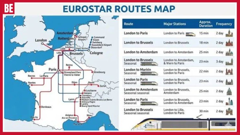
Eurostar has changed the way travelers from Britain travel across Europe, providing easy and speedy train service from London St Pancras International to some of the most exciting destinations on the continent. Be it romantic Paris or historical Brussels or even the lively cities of Amsterdam, modern Rotterdam and Lille, there are a number of choices that can be made depending on budget, time availability and choice of experience. This article discusses the various routes available, time taken by each route, stations, tickets and other tips about taking a Eurostar ride from London. If you are traveling for the first time.
What Happened During the June 2026 Heatwave?
The June 2026 heatwave became one of the UK’s most notable weather events of the summer. Early June was more changeable, with rain and showers affecting some areas. Temperatures were also closer to normal for the time of year. The weather pattern changed later in the month as high pressure brought longer periods of sunshine and warmer air.
Temperatures climbed quickly during the final week. Gosport reached 36.1°C on 24 June. Merryfield reached 36.7°C on 25 June. Santon Downham reached 37.3°C on 26 June before Lingwood in Norfolk recorded the verified maximum of 38.0°C.
The heat also affected Wales and Northern Ireland. Wales reached 35.1°C, while Northern Ireland reached 30.8°C. The nights were unusually warm too. Cardiff Bute Park recorded a minimum of 23.5°C, while Hastings recorded 23.2°C. Warm nights can make extreme heat harder to manage because homes have less time to cool down.
What Did the Met Office Predict and What Could Happen Next?
The Met Office uses different forecast periods to monitor UK weather. Short-range forecasts provide detailed information for the coming days. Longer outlooks focus on broader weather patterns. Both types of forecasts are useful, but they have different purposes.
The June event showed why weather forecasts can change. Early predictions could not guarantee the exceptional temperatures that eventually occurred. As high pressure strengthened and warmer air moved across the country, confidence in the extreme heat increased.
Another warm spell remains possible later in 2026. However, there is no confirmed date for another nationwide heatwave. Late August and early September are expected to bring more unsettled conditions in many areas. Rain and showers may affect parts of the UK, while temperatures should remain close to average overall.
BBC Weather, Regional Differences and Future Heatwave Predictions
BBC Weather can help people check local temperatures, rainfall, wind and general conditions. Local forecasts are especially useful during extreme heat because temperatures can vary considerably between different parts of the UK.
London, Manchester, Cardiff, Belfast and Edinburgh can experience very different conditions on the same day. Southern and eastern England can become particularly hot during prolonged high pressure. Coastal locations may remain cooler because of sea breezes, while higher areas can experience lower temperatures.
The June event showed these regional differences clearly. England reached 38.0°C, Wales reached 35.1°C and Northern Ireland reached 30.8°C. A single national temperature therefore cannot describe the weather experienced by everyone.
90 Day Weather Forecast UK 2026: How Reliable Is It?
A 90-day weather outlook can help people with long-term planning. It can show whether warmer, cooler, wetter or drier conditions may become more likely. However, it should not be treated as a precise forecast for every day.
Long-range predictions become less certain as the forecast period increases. A model may suggest above-average temperatures for a particular period, but that does not mean every day will be hot. Cooler days, rain and thunderstorms can still occur.
The same applies to heatwaves. A warm long-range signal does not automatically mean an official heatwave will happen. The timing and intensity usually become clearer when the event is closer. People should update their plans when newer forecasts become available.
How Can You Prepare for Another UK Heatwave?
Preparation becomes important when forecasts show a realistic chance of prolonged extreme heat. Simple changes can make hot weather easier to manage. People can adjust their daily routines and reduce exposure during the hottest hours.
Outdoor activities are often easier in the morning or evening. Walking, running and gardening can become tiring during the afternoon. Drinking water regularly can also help people manage prolonged hot conditions.
Homes can become very warm during a heatwave. Closing curtains or blinds during strong sunshine can reduce direct heat. Ventilation can help when the outside air becomes cooler. People should also check on those who may need extra support during extreme temperatures.
Useful preparation steps include:
- Check the latest local forecast.
- Monitor official heat warnings.
- Drink water regularly.
- Avoid strenuous activity during peak heat.
- Keep rooms shaded during the hottest hours.
- Ventilate rooms when outside air is cooler.
- Check on vulnerable family members.
- Give pets access to shade and water.
- Plan outdoor activities for cooler periods.
- Keep travel and event plans flexible.
Pros and Cons of Long-Range UK Weather Forecasts
Long-range forecasts can help people plan ahead. They may highlight periods that could be warmer, cooler, wetter or drier than average. This information can help with holidays, outdoor events and seasonal business planning.
Another advantage is early preparation. Event organisers can consider backup arrangements. Travellers can compare possible travel dates. Businesses can also think about potential weather-related risks before detailed forecasts become available.
However, long-range forecasts have limitations. They cannot guarantee the weather on a particular day months ahead. Predictions can change when new information enters the forecasting models.
Is Another UK Heatwave Possible in 2026?
Another UK heatwave remains possible during 2026. However, no specific future date can currently be guaranteed. Heatwaves require several weather conditions to develop together, including high pressure, warm air and prolonged sunshine.
The current outlook for late August and early September is more unsettled. Rain and showers may affect many parts of the country. Temperatures are expected to remain close to average overall, although short-lived warm spells can still develop.
Later September could become more settled in parts of southern and southeastern England. However, it is too early to call this a confirmed heatwave. The June event showed that conditions can change quickly, so regular forecast updates remain important.
Frequently Asked Questions
Is the Eurostar cheaper than a flight?
Eurostar can offer better overall value when airport transfers, baggage and travel time are included. Prices depend on the route, date and how early you book.
What UK stations does the Eurostar stop at?
Eurostar’s main UK departure station is London St Pancras International. Travellers from elsewhere in the UK can connect to St Pancras by domestic train.
What is the cheapest day to ride Eurostar?
Tuesdays and Wednesdays are often among the cheaper days to travel. Booking early and avoiding busy weekends can also help reduce fares.
Is Eurostar cheaper for over 60?
Senior fares are available on some continental Eurostar routes, but they do not apply to journeys to or from London. Over-60 travelers should check standard fares and available promotions.
What are the best Eurostar destinations from London?
Paris, Brussels, Amsterdam, Rotterdam and Lille are popular direct destinations from London. Each offers a different experience, from culture and food to shopping and short city breaks.
Conclusion
Traveling from London to Europe is made very simple and comfortable through the use of Eurostar trains with Paris, Brussels, Amsterdam, Rotterdam and Lille being some of the most common destinations. Travelers can end up saving quite a bit if they book early, travel on weekdays and compare travel times. Even though it is not always the most economical mode of transport compared to flights, the fact that Eurostar trains depart from the center of the cities and have a very simple journey process makes it worth the price. The departure station for the trains is London St Pancras International station.

Rip Off Britain is a highly rated BBC consumer program that looks into common challenges facing people in the UK. It addresses issues ranging from defective goods, holiday complaints, broadband problems, surprises, bills, bad customer care, among others, that may affect ordinary people. The real life stories of the program make understanding the challenges facing consumers easier, not to mention that lessons can be learned on complaining, looking at your contract, and taking care of your money. People will be looking for more about Rip Off Britain including where to find the latest show, presenters, BBC Website, among other things.
What Is the BBC Consumer Programme and Why Is It Popular?
The BBC consumer programme is built around real-life complaints and investigations involving products, services and businesses. Rather than concentrating on a single industry, it can cover everything from holidays and broadband to cars, property, food prices, insurance and household costs. BBC programme records show that the series has investigated a wide variety of consumer concerns over the years, making it relevant to people with very different purchasing experiences. Its broad subject range is one reason it has remained recognisable to UK audiences.
The programme is particularly effective because it presents complicated issues through personal stories. A consumer may have spent hundreds or thousands of pounds and still struggle to get a straightforward answer from a company. Another person may discover that the service they paid for does not match what they expected. By following individual cases, viewers can see how disputes develop, what evidence becomes important and why consumers should not automatically accept the first answer they receive from customer service.
Another reason for its popularity is the practical nature of the subject matter. Almost everyone buys something, pays bills, uses a mobile phone, books travel or signs a contract. This means that a programme about consumer problems can provide useful lessons even when a viewer has never experienced the exact same problem. Learning to save receipts, understand cancellation terms, check recurring payments and keep written records can help people prevent small problems from becoming expensive disputes.
BBC Website, Episodes and Today’s Episode
People searching for the official BBC programme website are often looking for episode information, the latest broadcast, presenter details or legitimate ways to watch the show. The BBC’s programme pages and listings are the best places to check current information because television schedules can change. Older search results may show programmes that have already aired, so checking the latest schedule can help readers find accurate broadcast times and episode descriptions.
If you are searching for today’s episode, it is useful to check:
- Today’s broadcast time and date
- The latest episode title and description
- Current BBC programme listings
- Available legitimate catch-up options
- Presenter information for the episode
- Whether an older episode is currently available to watch
The search for free online viewing is also common, but viewers should be careful with unofficial streaming websites. A page promising a free episode is not necessarily connected with the BBC and may contain misleading advertisements or unsafe downloads. The safest option is to use legitimate BBC viewing services when an episode is officially available. Episode availability can vary, particularly for older programmes, so viewers should always check the latest information rather than relying on outdated third-party listings.
Cast, Presenters and Presenters’ Ages
The phrase Rip Off Britain cast is frequently used by viewers searching for information about the people associated with the programme. Because this is factual television rather than a scripted drama, “presenters” is generally the more appropriate term. Angela Rippon, Gloria Hunniford and Julia Somerville are the broadcasters most strongly associated with the series, and BBC programme records list them presenting numerous editions.
The presenters play an important role in making complicated consumer stories accessible. They introduce investigations, speak to consumers, explain developments and bring in specialist information when necessary. Individual programmes can also feature journalists, experts, company representatives and members of the public. The people appearing can therefore vary depending on the subject of an episode. For example, travel journalist Simon Calder has appeared in holiday-related coverage, providing specialist insight into travel problems.
Searches for Rip Off Britain presenters ages are also common. Angela Rippon, Gloria Hunniford and Julia Somerville have all had long careers in British broadcasting. Their professional backgrounds are often more useful to readers than simply listing an age that will become outdated. If an exact age is included in an SEO article, it should be calculated from reliable current biographical information because a presenter’s age changes every year. Career history and programme involvement provide more lasting information.
How to Contact the Programme With a Consumer Problem
The search how to contact Rip Off Britain is particularly relevant for viewers who have experienced a serious consumer dispute. Someone may have bought a product that developed a major fault, experienced problems with a holiday booking, faced an unexpected charge or struggled to resolve an issue with a company. The programme has historically invited members of the public to share consumer stories, although submitting a case does not mean that it will necessarily be selected for television.
Before making contact, prepare the facts carefully. Explain what you bought, who supplied it, when the purchase happened, how much you paid and exactly what went wrong. Include a simple timeline showing when the problem occurred, when you complained and how the company responded. A short, organised explanation is much easier for a production team to understand than a long message containing every detail from the beginning of the dispute.
Evidence is extremely important. Keep receipts, invoices, contracts, booking confirmations, screenshots, photographs, emails, letters and complaint reference numbers. If the company made an important promise, keep the written evidence showing what was said. Avoid sending unnecessary passwords, bank details or other sensitive information. Most importantly, contacting a television programme should not replace the company’s own complaints procedure. Continue pursuing the appropriate formal route while considering whether your case might be relevant to consumer television.
Website Checker and Online Consumer Safety
The phrase Rip Off Britain website checker can be confusing because people may use it to search for a tool that checks whether a website or business is genuine. Consumers should not automatically assume that a website using the programme’s name is officially connected with the BBC. Search-engine results can include independent websites, old pages and commercial sites that use popular programme-related terms to attract visitors.
When checking an online seller, look carefully at the company’s identity, contact details, payment arrangements, terms and conditions and cancellation information. Be particularly cautious when a website pressures you to make an immediate purchase or claims that an offer will disappear within minutes. A very large discount is not automatically proof of a scam, but it should encourage you to investigate the seller before paying. Check the complete cost rather than focusing only on the headline price.
Consumers should also be careful when searching for free television content online. A website claiming to provide an episode without charge is not necessarily an authorised BBC service. Avoid downloading unknown software or providing financial information merely to watch a programme. When looking for BBC programme information, use official BBC resources. When checking a retailer, investigate the retailer itself. Separating these two tasks can help prevent consumers from confusing genuine programme information with unrelated websites.
Real-Life Consumer Problems, Benefits, Pros and Cons
The programme has covered many different types of consumer problem, which is one of its strongest features. Holiday disputes can involve airlines, hotels, travel companies and transfer providers, while broadband complaints can involve service speeds, outages, contracts and price changes. Property investigations can involve defects in new homes, while vehicle stories may involve questions about condition, history or safety. The BBC’s programme records demonstrate this wide-ranging approach to consumer journalism.
One major benefit is that viewers can learn from someone else’s experience. A person watching a holiday complaint may decide to save booking documents and photographs. Someone watching a broadband investigation may start recording service problems and keeping customer-service reference numbers. A homeowner may realise the importance of photographing defects and maintaining a written timeline. These lessons can be useful even when the viewer never experiences exactly the same situation.
There are also limitations. Television has limited time, so a complicated dispute may have to be simplified for viewers. A case that appears similar to your own could involve different contracts, dates, companies or evidence. The programme should therefore be treated as consumer education rather than individual legal advice. Its value comes from showing viewers what questions to ask and what evidence can matter, while consumers should check current official guidance before taking significant action.
Is the Programme Worth Watching?
Yes, it is worth watching for anyone interested in consumer rights, practical money-saving ideas and real-life complaints. Its biggest advantage is that it discusses issues people can actually encounter. A problem with a holiday, phone contract, household bill, appliance or property purchase can be stressful because consumers often do not know where to begin. Seeing a similar situation presented clearly can make the problem feel more manageable.
The programme can also encourage better habits before a complaint ever happens. Before making a major purchase, consumers should research the seller, compare the total price, read important terms and save evidence of what was advertised. After purchasing, they should check bills, monitor recurring payments and act quickly when something appears incorrect. For expensive purchases, keeping photographs, receipts and written communications can make a substantial difference if a dispute develops later.
However, viewers should not expect television coverage to solve every complaint. A production team cannot investigate every case, and a business is not automatically required to change its position because a television programme becomes involved. The strongest approach is to use the programme as an educational resource while handling your own complaint through the appropriate channels. Overall, it offers useful consumer awareness and encourages people to become more confident, organised and careful with their money.
Frequently Asked Questions
What has happened to Angela Rippon?
Angela Rippon stepped back from the programme after many years as a presenter. Louise Minchin later joined the presenting team.
Why is it called Rip Off Britain?
The name comes from the phrase “rip-off”, referring to something considered unfair, overpriced or poor value.
Is Rip Off Britain still running?
Yes, the BBC consumer programme has continued with changes to its presenting team. Check the latest BBC schedule for current episodes.
Who were the three original presenters?
The original presenters were Angela Rippon, Gloria Hunniford and Jennie Bond. Julia Somerville later replaced Jennie Bond.
How can I contact the programme?
Check the latest BBC programme information for current contact details. Prepare your consumer story and keep supporting evidence such as receipts and correspondence.
Conclusion
Rip Off Britain continues to be a valuable BBC consumer programme for those who need practical information on complaints, bad deals, defective goods, vacations, and customer services. Practical investigations presented in the programme may help the viewer understand his/her rights and become more confident in dealing with firms. Moreover, Rip Off Britain has been evolving and new presenters have been added to the already famous team of the programme. Be it searching for programmes, today’s programmes, presenters or ways of contacting the production team, one should always consult current BBC information. But above all, one should save receipts, contracts.

England is an excellent starting point from London since there are many historical cities, royal sights, picturesque villages, coastline, and beautiful landscapes that you can easily visit within a short distance from the capital. You can see Oxford, Bath, Brighton, Windsor, Cotswolds and many other destinations without even moving from the hotel. It all depends on your interests, budget, transport, and the amount of time you have to spend on it. Certain destinations are best suited for rail, and some are better to visit by car. Honeymooners can choose romantic destinations, parents can visit family-friendly destinations, and visitors who don’t have a car have lots of options.
Best Day Trips from London by Train and Without a Car
Travelling by train is often the simplest way to leave London for the day. You avoid traffic and parking, and many historic destinations have stations close to their main attractions. Oxford is one of the strongest choices, offering famous university buildings, museums, historic streets, cafés and traditional pubs. You can spend most of the day walking between sights, making it particularly convenient for independent travellers. Cambridge offers a similarly historic atmosphere, with beautiful colleges and the River Cam providing opportunities for riverside walks and punting.
Windsor is another easy option, especially if you want royal history without a long journey. Windsor Castle can form the centrepiece of the day, followed by a walk through the town or along the Long Walk. Brighton is better for visitors who want a seaside atmosphere, with the beach, pier, Royal Pavilion, Lanes and restaurants all within a manageable area. Bath is slightly farther away but rewards the journey with Roman heritage, Georgian architecture and a compact centre that is easy to explore on foot. These destinations are also among the best choices for anyone searching for day trips from London without a car.
Best Day Trips for Couples and Families
For couples, Bath is particularly appealing because its elegant architecture, Roman history, riverside setting and restaurants create a relaxed atmosphere. Cambridge is another good choice for couples who enjoy historic buildings and leisurely walks, while the Cotswolds are ideal if you prefer villages, countryside and traditional pubs. Brighton suits couples looking for something more energetic, with its seafront, independent shops, restaurants and lively atmosphere providing plenty of flexibility.
Family travel requires a slightly different approach. Children generally enjoy destinations that combine a major attraction with open space and opportunities for breaks. Windsor is a strong choice because the castle provides a clear focus for the day, while Brighton offers the seaside, pier and plenty of places to eat. Older children may enjoy Stonehenge because its ancient monument can make history feel more tangible. Oxford and Cambridge can also work well for families with older children who enjoy history, architecture or literature. The key is to avoid packing too many attractions into one day.
Best Day Trips by Car and Unusual Places to Visit
A car becomes most useful when you want to explore places that are spread across a large area. The Cotswolds are the clearest example. Rather than being one town, the region contains numerous villages, countryside roads and viewpoints, so driving gives you the freedom to create a route that suits your interests. You can combine several villages without depending on limited local bus services. The Sussex coast can also work well by car, allowing you to combine Seven Sisters with nearby coastal towns, Rye or Camber Sands.
However, driving is not automatically better. Traffic leaving London can be heavy, and parking in popular historic cities can be expensive or inconvenient. For Oxford, Bath, Cambridge and Brighton, the train may actually save time and stress. A car is most valuable when it gives you access to places that are otherwise difficult to reach. If you spend most of your day in traffic or searching for parking, the flexibility of driving disappears.
If you have already visited the obvious destinations, consider unusual day trips from London. Rye offers atmospheric historic streets and a slower pace, while Margate combines seaside scenery with art and independent businesses. Winchester provides fascinating medieval history without the scale of larger tourist centres. Stratford-upon-Avon is particularly suitable for Shakespeare enthusiasts. These destinations can be more rewarding for repeat visitors because they offer a different atmosphere rather than simply another collection of famous landmarks.
Coastal, Countryside and History Escapes
Seven Sisters is one of the strongest choices for travellers who want dramatic scenery rather than museums and historic buildings. The white chalk cliffs and coastal paths provide excellent opportunities for walking and photography. However, this is an outdoor experience, so comfortable footwear and suitable weather are important. The paths can become muddy, and exposed sections can be windy. It is therefore worth checking the forecast before making the journey.
The Cotswolds offer a completely different landscape, with stone villages, rolling hills and country pubs. Their charm comes from slowing down rather than ticking off attractions. A common mistake is trying to visit too many villages in one day, which can turn a peaceful countryside experience into a long driving schedule. Choose a small number of places and allow time for lunch and walking.
History lovers have an impressive range of options. Canterbury is ideal for medieval heritage and its famous cathedral, while Salisbury works well for visitors interested in historic architecture and Stonehenge. York is farther from London but can be reached by fast train and offers a remarkable medieval centre, York Minster and historic city walls. Winchester is a more compact alternative, with its cathedral and connections to medieval England. Each destination offers a different period of British history, so choosing according to your interests will produce a more rewarding experience.
Day Trips from London to Europe
A trip from London to Europe is possible if you are willing to accept a longer travel day. Paris and Brussels are the most obvious choices because high-speed international trains make them accessible from the capital. The attraction is clear: you can experience another country’s architecture, food and culture without changing hotels. For repeat visitors who have already explored several English destinations, this can be an exciting addition to a London holiday.
The drawback is that international travel takes more planning. You need to allow time for international travel procedures, check passport and entry requirements, and leave room for possible delays. A European day trip therefore makes more sense when the international experience itself is your main goal. If you simply want somewhere beautiful to visit for the day, Bath, Oxford, Brighton or Cambridge will normally provide more relaxed sightseeing.
For travellers staying in London for only two or three days, I would generally stay within England. You will have more time to explore and less risk of losing valuable hours to transport. With a longer stay, however, Paris or Brussels can provide an enjoyable change of culture and scenery. Plan your return carefully and avoid scheduling something important immediately after your international journey.
Practical Planning Tips, Reddit Opinions and FAQs
Travel discussions on Reddit often highlight a practical point that is easy to overlook: the most impressive destination is not always the best one-day destination. Travellers frequently recommend places such as Oxford, Brighton, Bath and Canterbury because they are relatively straightforward to reach and explore. The Cotswolds are often discussed differently because seeing several villages without a car can be difficult. This reinforces an important rule: consider transport and geography before choosing a destination. A beautiful place can become frustrating when most of your day is spent changing buses or driving between scattered attractions.
The following practical points will help you plan a smoother day:
- Check train times and engineering works before travelling.
- Start early at popular destinations.
- Choose two or three main attractions rather than trying to see everything.
- Wear comfortable shoes and take a waterproof layer.
- Research parking if you are driving.
- Check attraction opening times and booking requirements.
- Leave enough time for lunch and unexpected stops.
- Plan your return journey before laveing London.
Frequently Asked Questions
What is the easiest day trip from London?
Windsor, Oxford, Cambridge and Brighton are among the easiest choices because they have convenient transport links and compact town centres. They are suitable for first-time visitors and travellers without a car.
Which London day trips are best for couples?
Bath, Cambridge and the Cotswolds are excellent choices for couples. They offer romantic walks, attractive architecture, scenic countryside, cosy restaurants and plenty of opportunities to explore at a relaxed pace.
Which destinations are best reached by train?
Oxford, Bath, Brighton, Cambridge, Windsor, Canterbury and York are strong train-friendly options. Many have railway stations with easy access to their main attractions.
Which places are good for families with children?
Windsor and Brighton are excellent family choices because they offer attractions, outdoor spaces and plenty of places to eat. Stonehenge can also be fascinating for older children interested in ancient history.
Can I take a day trip without a car?
Yes. Oxford, Cambridge, Brighton, Bath, Windsor and Canterbury are particularly convenient by train. Their main attractions can generally be explored on foot, reducing the need for local transport.
Conclusion
There are a variety of different places around London that provide great opportunities for excursions both for leisure and business travelers. Starting from the historical cities of Oxford and Bath up to bright and dynamic Brighton, majestic Windsor, and tranquil Cotswolds, London has a lot to offer. The train-friendly destinations will suit those who do not have their car, and the rural ones will require a bit of driving. The couples will enjoy romantic landscapes and small picturesque towns, while families with children may select spacious and entertaining locations. It is even possible to travel to Europe depending on how one plans his/her vacation. In conclusion, everything depends on your preferences.

Best Places to Visit in UK Top Destinations

Vernon Kay Biography Age Wife Career

Best Beaches in UK Top Places to Visit
-

 Uncategorized2 months ago
GB News Presenters Female Current Hosts Newsreaders and Journalists
-

 Uncategorized2 months ago
Good Morning Britain Presenters Today’s Hosts and Political Team
-

 Uncategorized2 months ago
Shefali Oza Biography Age BBC Career Husband and Net Worth
-

 Uncategorized2 months ago
Rip Off Britain Presenters Ages Cast Hosts and Everything You Need to Know
-

 Things To Do2 months ago
Universal Studios Great Britain Opening Date Rides Map and Location
-

 Uncategorized2 months ago
Pride of Britain Awards How to Nominate a UK Hero
-

 Uncategorized2 months ago
Emily Campbell Weight lifting Career Olympic Medals and Life Story
-

 Uncategorized2 months ago
Great Britain at the Winter Olympics Medals Full History